The Eifel - Ardennes Green Route

Wapping

Moderator
Moderator
Joined
Oct 21, 2005
Messages
79,225
Reaction score
3,935
Location
Wapping, London
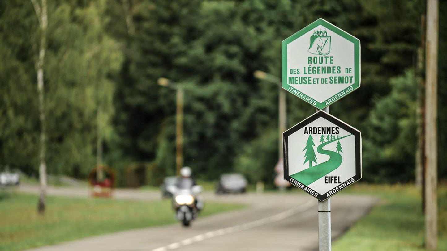
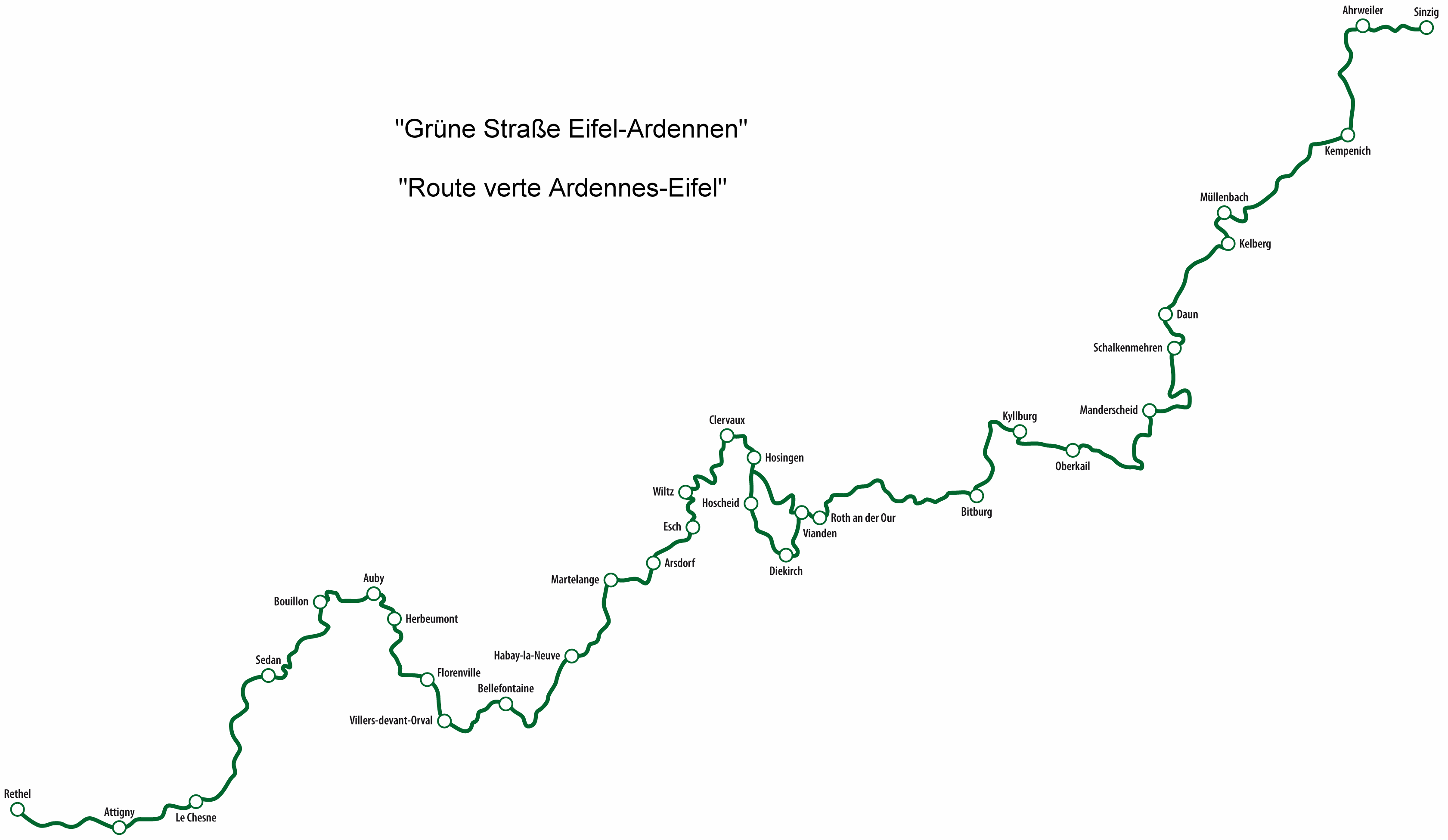
The Eifel-Ardennes Green Route or Eifel-Ardennes Green Road (German: Grüne Straße Eifel-Ardennen, French: Route Verte Ardennes-Eifel) is a cross-border, tourist route, about 500 kilometres long, which links the Ardennes to the Eifel. It runs from France via Belgium and Luxembourg to Germany mainly on quiet by-ways.


For seveveral years I've been seeing signs for this route but never really bothered to look into it before now. It looks OK and would make a reasonably pleasant way to cross the Ardennes into the Eifel

EVEA-Logo-wwweveade_1.jpg


D31%20Legendes%20Sign.JPG


gruene_strasse_mit_orten-neu2.gif
 
Seconded and fully recommended :thumby:

Ridden fully in bits'n pieces at various times ...

Thanks Richard :thumb

:beerjug:
 
Same here, riden several parts of the route over the years without realising there's an official route, stayed in Florenville a couple of times, plenty of bars and eateries and all open, which is more than can be said for a couple of mile south across the border.
 
Cheers, Micky.

I must have ridden most if not all of it in chunks or pieces over the years. The whole area is one of my favourite touring destinations, better than the Alps to my mind. Why? Well, it's closer for starters, perfect for a quick three or four days away. There is an excellent mixture of roads, from very fast open sweepers, to nadgery little roads into the forests with sometimes shall we say, 'interesting' road surfaces, hairpins and enough 'technical' challenges to leap out and bite the unwary to keep a bod on their toes. Rideable though on anything from a GS, to a FireBlade to a bicycle.

I'll try to remember to sit down and cut the route into a Garmin friendly file, sharing it with bods here.
 
Whilst I'm at it, here's the link to 'LA ROUTE DES LEGENDS' whose signs I have seen, too:

http://www.visitardenne.com/all-access/fr/circuits/la-route-des-legendes/

http://www.visitardenne.com/all-access/fr/circuits/la-route-des-legendes/detail_199

Yes, it's in 'foreign' but it doesn't take much imagination to work out the route and get a reasonably good idea of the suggested stopping-off points with things to see. For example, via the second link, you'll find a good enough map of the full route. Click on the places it the left hand column and they'll appear on the map, along with pictures of what to see.

By Christ, you don't half stop me getting jobs done at home.....thanks.

Rode a lot of this area for rhe first time last year after "starting" from Two Wheel Moorings B&B in Dun Sur Meuse (as recommended here somewhere) Loved it.
 
and more useful info for a potential Easter weekend using Bouillon as a base with an extension just for me into Germany
 
I'm watching this tread evolve :thumb

Ah ... I know what you mean :thumb

It's a great area, you can go there for the weekend, or a couple of weeks. The roads around must've been designed by motorcyclists. Loads of excellent hotels, all biker friendly ... you simply, quite simply, can't go wrong :thumby:

:beerjug:
 
I have created the route in BaseCamp, along with its optional loop Hosingen (start of loop) - Hoschied - Vianden (end of loop) - Roth an der Our. It is 285 miles, starting from Rethel in France; the roads taken look OK, so easily doable in a day. As it takes you straight past the 'ring, it might well make a reasonably nice way to get there from NE France. From Sinzig at the Gernan end, it's across the Rhine by ferry and onwards to the east....

The route is hosted on Dropbox as a .gpx file, created on a Mac. When downloaded it should open straight up in BaseCamp or in Mapsource. Anyone using a Mac might find that it opens as a load of words in a text file. Do not panic! For some unknown reason the original .gpx file can gain a .txt extension. Download the file as normal, save it and then rename it by cutting off the .txt bit but leave the .gpx bit. All should then be good.

https://www.dropbox.com/s/8btc02frp...ethel to Sinzig (with optional loop).GPX?dl=0

Richard

PS It might be obvious, but... if you are starting from the German end, you'll need to reverse the route.

PPS I'll create the Route des Legends, too.....
 
thanks for this, saved me a bit of work as this route looks a really good day trip to get from Bouillon towards Koblenz - I just deleted the 1st three shaping points and bingo!
 
Are you on a retainer from BHT Richard for all this input in to UKGSer?

:beerjug:

Once a year, I get to use the whip

cover.gif


.....this route looks a really good day trip to get from Bouillon towards Koblenz - I just deleted the 1st three shaping points and bingo!

Excellent. I had forgotten to convert the waypoints to shaping points. Have a good time and let us know how it goes, please.
 
Thank you Wapping :thumb. Your gpx is an 8hr 24 min (285 mile ride), so certainly not a weekend ride for me, plus I must get there... and back. Its a tempting trip for a week's holiday.
Many thanks for your input.
 
Will be doing Eifel again this year. Incorporated in to our route through Germany and over to Austria/Italy. Eifel is an often bypassed area in the hurry to get to 'good roads'. Only 3 hours from Amsterdam ferry terminal and your in the top end of German Eifel park and great roads.
 
Thank you, GrinningGSer

I think Garmin's estimation of the time is maybe overly cautious. I regularly see the estimated journey time drop between that displayed in BaseCamp on my Mac to that displayed on my Nav V on import. That being said, it's probably not a 'One day ride' route for wandering out of the door at 11 and then meandering along. The good thing about it is that it can be used for at least two purposes:

1. A to B down some interestingly decent roads, avoiding motorways.... as so often requested for by bods on this site

2. A two or three day or longer meander through some attractive scenery and through some nice enough towns, to make a holiday in its own right

Which I guess is what the route's German and French collaborators hoped for when they created it?

What I hope the thread shows is that it's possible to see a roadside sign and Google it up. Then, with a bit of effort surf around to find some more details to work with. Just as a quick experiment I put three simple words: 'Ardennes to Eifel' into Google, it being the sort of question and request for route help we see here quite often. Besides Google's own standard map popping up, which is a useful enough place to start, up popped the Wikipedia entry on the Green Route and below it entries for the German and French websites. From there it's just a matter of joining the pieces together.

PS Living reasonably close to the Chunnel and the Dover ferries has its advantages, I'll admit that.
 
Just downloaded your route Richard. As you say, it opens up in a Notepad file but I deleted the .TXT suffix and saved it as a GPX file on my wheezy old laptop. Opened up Mapsource and then the file. Bob's yer uncle and Fanny's yer aunty. If I can do it ...

Thanks for this. Just need to find time to head over there!
 
I was planning to ride around there for while now. Route downloaded. Thanks a lot Wapping!


Back
Top Bottom