Glitches in Garmin V8 - open letter to Garmin

When I started using a navigator 4 years ago (SP3) I quickly learned that both the woice prompts and the pop-up instructions where very often erroneous.

Most common error was that that the written or spoken text was "turn left" while the picture or map clearly showed a "turn right" situation.

After a while a found that 90% of the errors came where I had put a route waypoint exactly in a crossing/junction. Both examples in this thread fits into this category!

Rule 1: Never put a route waypoint in a junction/fork/crossing. Always put it on the road between the junctions.

Enough errors remains for me to have voice guiding & pop-ups switched off always. Today I use only the simplified "overlay" map screen guiding on my 276C. It shows me only the map plus time & distance to next change of direction. Almost no bugs nor confusion. :thumb
 
I`ve had quite a few problems with V8 city navigator, using a saved route, many like this, i.e. map routed showing 3rd exit, pop up showing 2nd exit and voice instruction telling me to take the 1st exit. I`ve had many similar to this, told Garmin about this and problems with signal/reception in an email with full details and grid ref, but never had any info from them about whether they were doing anything about it, except the signal/reception problem was resolved with a firmware upgrade.
I only recall coming across 1 incorrect routing instruction with V7 city select. Maybe they`ve had alot of problems with V8 as it was delayed several times before release from what I understand. Most the time I`ve noticed the incorrect instructions and zoomed out to check the map before making a decision on which direction I should take, but when I haven`t had time or when my attention was required for more important tasks like controlling the vehicle I`m in, it`s been a real pain in the arse, especially at busy junctions, leading to taking the wrong route :( .
Apart from these problems, I really like my 276c and V8, much prefer it to a C310 I was asked to use at work for a couple of weeks.
 
PanEuropean said:
The software engineers are following this thread with considerable interest, and started looking into the matter yesterday.
Just another datapoint...

I haven't tried replicating all Richard's examples, but have just tried out a short route that takes in the roundabout on the outskirts of Lillers. I started the route approx 1.4 miles away (east) on the A26 and finished it just prior to the split between the D916 & D183 approx 2 miles south of the roundabout. My 2720 running Software v5.00, TTS voice Emily v1.30 and CN8 NT+ v8 in simulation mode announced the directions perfectly, including the magic phrase "enter roundabout and take fourth exit to D-nine-hundred-and-sixteen". The onscreen prompts and mapped route matched too.

BTW, any idea how I can run a route simulation other than in real time?

Phil
 
st13phil said:
BTW, any idea how I can run a route simulation other than in real time?

Phil

How about "amending" the speeds in preferences on the PC, and then download the maps onto the GPS. It'll probably reset the speeds once you've been out on the road. :mmmm
 
HMR said:
When I started using a navigator 4 years ago (SP3) I quickly learned that both the woice prompts and the pop-up instructions where very often erroneous.

Most common error was that that the written or spoken text was "turn left" while the picture or map clearly showed a "turn right" situation.

After a while a found that 90% of the errors came where I had put a route waypoint exactly in a crossing/junction. Both examples in this thread fits into this category!

Rule 1: Never put a route waypoint in a junction/fork/crossing. Always put it on the road between the junctions.

Enough errors remains for me to have voice guiding & pop-ups switched off always. Today I use only the simplified "overlay" map screen guiding on my 276C. It shows me only the map plus time & distance to next change of direction. Almost no bugs nor confusion. :thumb

Thanks.

It seems I am not alone with the device's mistaking left and right. Yours is certainly a suggestion but I am not sure that it fits completely comfortably. For instance, the roundabout problem (leave by first exit, not fourth) does not fit at all. Nor does it fit particularly well with other errors, for instance silence at T junctions, encountered when I have simply plotted, say, a 200 mile route with no specific waypoints at all. I guess that these 'other errors' fit within the 10% leeway that your 90% prediction suggested?

Do you have a suggestion as to how far from the junction to put the waypoint?

It would be interesting to hear if other have experienced this 'drop-out' of instructions when (and if) a waypoint is right on top of a junction?

I do not use specific waypoints that often but possibly others (whose routing I have borrowed and loaded) do., so maybe I am picking up the error from their method of plotting routes?

When plotting routes on my PC I usually just use the routing tool to click on the route at intervals just to make sure it keeps me on the road I want to take. Usually these clicks are on the highway itself, I cannot remember clicking right on top of a junction. In fact I would say that I usually take care to click well away from the junction just to make sure the route takes me around it correctly.

Do you get a message that says for instance, 'Waypoint on right' instead of a 'Turn left / right' instruction at the junction? I can't say that I have ever heard one.

Not having the voice instruction / warning on may work well in the wide expanses of Sweden, where by-and-large, junctions on roads are reasonably clear for miles ahead. But not having it on and working in the narrower and more 'jiggly' D roads of France, with lots of junctions, cross roads, villages etc. is a bit of a nuisance. Plus, I paid a decent amount of money for a quality system, so I want it to work well with all of its functions, not switch off one that is troublesome.

If this thread helps Garmin to fix the waypoint at junctions / lack of voice / left and right problems I will be happy.

Richard
 
Whilst I look forward to Michael's reply, I think that this is quite likely to be a NavTeq problem, not specifically a Garmin issue.

Navteq provides much of the mapping data Garmin uses. In each country they usually work with a local partner. In the UK that's Ordnance Survey and, accordingly, UK data is pretty accurate (provided it's up to data - if that makes sense).

For other countries, the data quality can be somewhat poorer and, although the roads themselves maybe about right, some of the road attributes aren't. Road attributes are everything from addresses and road signs to turn restrictions--for each segment of road - a huge amount of data.

I too have been told by Betty to 'turn right' when she really meant 'turn left' and I've always assumed that the road attribute is incorrect.

Let's see what Michael and/or Garmin respond with.

Greg
 
Thanks Shedracer and Phil. Phil for running the simulation and Shedracer for confirming that I am not going mad.

So we now have a mixture, someone who has a similar problem in V8 and a simulation where the problem at the roundabout doesn't occur. I am starting to lean towards the theory (however unlikely) that the roundabout problem is caused by a positioning error somehow, with the device perhaps misinterpreting the bike's position and direction of travel :nenau 
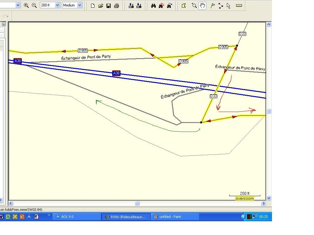
This might explain why it works OK in a simulation but not on the road. It still seems odd that the error repeats at the same roundabout every time whilst the map, pop-up and vehicle position indicator all seem to look OK and the route correctly marked.

I think the problem is more pronounced since I installed V8 or maybe I am just doing more miles since installing V8 :nenau

I am off on various trips (Le Mans, Picos and Dolomites) before September so will be trying to plot the routes with care and then work out exactly how, where, why and if the problem(s) happen.

I will be joined on the Dolomites jaunt by two other bikes with similar navigation and bike-to-bike so we will be able to keep a good track of things as they unfold. Similarly, a friend who has the same V8 problem, is on a eight day trip around central France in a week or two. I will ask to see how he gets on.
 
Wapping said:
I guess that these 'other errors' fit within the 10% leeway that your 90% prediction suggested?
Maybe I should have written 70/30 instead of 90/10.

Wapping said:
Do you have a suggestion as to how far from the junction to put the waypoint?
Anywhere except exactly in the junction.

Wapping said:
Not having the voice instruction / warning on may work well in the wide expanses of Sweden, where by-and-large, junctions on roads are reasonably clear for miles ahead.
I agree. But it's not a nation thing. It's more an issue of me always riding on small countryside roads. Very seldom in big cities or motorways.

This problem doesn't seem to be related to map version. I have used V4, V6 & V8 and the only difference is that the problems shows in different places. Frequency is the same as far as I can see.
 
HMR said:
Maybe I should have written 70/30 instead of 90/10. Anywhere except exactly in the junction.
I agree. But it's not a nation thing. It's more an issue of me always riding on small countryside roads. Very seldom in big cities or motorways.
This problem doesn't seem to be related to map version. I have used V4, V6 & V8 and the only difference is that the problems shows in different places. Frequency is the same as far as I can see.

OK :thumb
 
I have just checked with my friend who has similar problems.

(1) He does insert waypoints on the junctions, so maybe that is the answer? Or at least a part.

(2) However, he sometimes encounters the same problem when he simply asks the device to calculate a route home in London from, say, Suffolk – a distance of perhaps 120 miles. We assume that the device does not need to insert waypoints in its own single route calculations, yet the voice routing errors occur.

These errors are not because new roads have appeared or new junctions on roundabouts. They mirror the problems highlighted above.

He, like me, is not entirely happy with turning off the voice and using the device simply as a map.

(A) It’s not right. The thing should work.

(B) It’s arguably not entirely safe to stare at a small map whilst riding at ‘progressive’ speeds.

He is certainly going to drop the habit of inserting waypoints on junctions, so let’s see what happens.

Richard
 
Follow up for HMR

HMR

You suggested not inserting Waypoints on junctions.

Now that I am at home and looking at Mapsource I can see that I do not use the Waypoint Tool too often but I do use the Route Tool when plotting routes.

How does this stack up with the do not insert Waypoints on junctions theory? Or are Waypoints the same as clicks with the Route Tool?

However, I do use other peoples' routes as well, so they may well use different methods to plot a route. Maybe I am importing their methods and getting the errors that way?

Richard
 
Follow up for HMR

I have just looked at the roundabout example I gave.

There is a Route Tool click on the roundabout but it is on the exit road, not at the entry point. The voice error occurred on our approach and entry to the roundabout (‘Take first exit’, she said, which is wrong) not at the exit. The corrected exit instruction, once we had passed the first exit, was given correctly.

This would seem to dampen your theory.

However, to warm your theory, I have also had a look at the other example I gave with the silent left turn. At that junction there is a Route Tool click, right on the junction and the voice was indeed silent.

So 50 / 50.

Both routes were created for me by someone else, I simply copied them.

Unfortunately, I cannot now recall whether other junctions, which may have similar Route Tool clicks on them, were similarly silent? You tend not to remember the ones that work, only the ones that do not.
 
Hi Richard:

Some follow-up questions from the engineering team:

1) Did you create the route or routes that took you through the three problem areas using MapSource, and then download these routes to the GPSRs, or did you create the routes directly on the GPSR?

2) Are any of the three problem areas that you mentioned close enough to you (or to another interested forum member) to allow you to create a route using the GPSR only, and run through the problem area again to see if the guidance mistake repeats when the route is created on the GPSR?

Lastly, the engineering team members compliment you on the thoroughness of your documentation of the problem.

Michael
 
HMR said:
...Most common error was that that the written or spoken text was "turn left" while the picture or map clearly showed a "turn right" situation. After a while a found that 90% of the errors came where I had put a route waypoint exactly in a crossing/junction. ...

Rule 1: Never put a route waypoint in a junction/fork/crossing. Always put it on the road between the junctions.

I think your suggestion - to not put route waypoints on top of places where 'leg changes' will need to be made - is a good one, however, I don't think it accounts for the problems being described here.

If you have inserted a waypoint in a route by creating a new waypoint and then including it in a route (for example, start and end points of route are A and D, you create a waypoint called B and insert it in the middle), the GPSR will call your attention to the fact that you are approaching, and later passing, the intermediate waypoint. I am pretty sure that Richard and the other members of his touring party would have noticed this, had it been the case with these three problem areas.

If you insert a waypoint into a route by using the rubber band tool, and you are working at a very wide zoom level on the map when you drag the route line around, there is always the risk that you might drop the route line on the wrong side of a divided highway, and not notice that you now get routed past that point, then asked to double back in order to cross over the place where you dropped the route line. The folks who write the MapSource application have put some algorithms in there to reduce the possibility of this happening, however, for the algorithm to work properly, it has to detect that a 'doubling back' has taken place.

If you follow HMR's suggestion of always inserting your intermediate waypoints more or less half-way between towns or cities, you will greatly reduce the risk of an unwanted excursion in the route being created as a result of an accidentally misplaced intermediate waypoint.

In summary - it's a good suggestion, but not for the reason originally given.

Michael
 
PanEuropean said:
Hi Richard:

Some follow-up questions from the engineering team:

1) Did you create the route or routes that took you through the three problem areas using MapSource, and then download these routes to the GPSRs, or did you create the routes directly on the GPSR?

2) Are any of the three problem areas that you mentioned close enough to you (or to another interested forum member) to allow you to create a route using the GPSR only, and run through the problem area again to see if the guidance mistake repeats when the route is created on the GPSR?

Lastly, the engineering team members compliment you on the thoroughness of your documentation of the problem.

Michael

Hi Michael,

(1) The routes were created for me by a friend of mine. He was on one of the other three bikes mentioned and also suffered the same problems. To the best of my knowledge the routes were created on his PC. I will ask him tomorrow, just to be sure. If you hear nothing more then they were PC created.

(2) Sadly no. I'm stuck here in London and the problems are a better part of a half a day's ride away in France. If I get half a chance I will do as Garmin are asking but it will not be for a couple of months at least. Sorry.

In passing, I did chat to my friend earlier this evening. There were a couple of roundabouts where the 'Take first exit' error came up and certainly several 'silent' junctions or 'silence' at significant road deviations. Rather than try to guess where they were it's probaly best to stay with the ones that we know were wrong.

However, I am going to make an effort to narrow down where the Y junction error happened, running over the motorway. I can probably work it back from the route map and some written direction notes (it always pays to have good old paper instructions on the top of the tank bag and a map - but don't tell Garmin ;)

Richard

richard
 
The Y junction error

Michael,

Here is the Y junction error. On the map it looks more like a T but I guess you get the picture. In its way it is the most impressive of the three errors so I am glad I have found it.

Yjunctionerror.jpg


Details as best as I can describe them.

(1) As you can see the route has two sets of direction arrows. This is because we were planning a circular ride out, returning in the afternoon along some of the same roads we used in the morning. In the end we did not return along the same route, so I have no way of knowing if the error occurres in reverse. I do not think this double routing caused the problem.

(2) The planned route was to ride along the D905 and turn right onto the D33 and continue, avoiding the motorway. As far as I can recall the voice and map instructions to turn right onto the D33 came through OK.

(3) I was leading and can clearly remember (it was only last Sunday)being confused soon after joining the D33 as the device was saying ‘Keep right’ and ‘Take ramp right’ when all I could see were signs to the right down to the motorway, where I knew we did not want to go. It is only a few 100 meters from the point where we joined the D33 and the point where it splits and I could plainly see that the voice instructions could not be correct.

(4) The device’s map and pop-up screen were both showing the route going left, down onto a ramp and staying on the country road.

(5) I have indicated the correct route with a scribbled red arrow and drawn the incorrect ‘voice’ instructed route in green. As you can see, the green voice route is a ramp and feeder road down to the motorway and was definitely not on the programmed route at all.

(6) I clearly remember stopping on top of the motorway, a few meters way from the split in the road, staring at the map on the device (which was right), looking at the road signs, one directing traffic to the motorway to my right and the other directing non-motorway traffic left. In my headphones was a voice saying, ‘Take ramp right’ and me thinking it could not possibly be correct.

(7) My two friends with the same route on their Garmin devices joined me, equally baffled by the voice instruction but pointing out that the left hand split must be the correct route, as shown on our devices.

(8) As soon as we took the left hand fork (ignoring the voice instructions) the device, map and voice continued as if nothing had ever happened.

I have attached the Garmin route file in full.

The manoeuvres between the D905 and the D33 to the Y junction are directions 37 through 40.

The point of the Y (T?) is at N47 17.845 E4 48.201

Richard
 

Attachments

  • RV06-3RideoutBeaune.gdb
    98.6 KB · Views: 15
Was the route plotted on a PC or on the device? Question from Garmin

Michael,

I am not sure if this is relevant:

Whilst I am still sure the routes were plotted on a PC, there is of course the real possibility that an 'Off route....recalculating' message may have come up earlier in the route. I am reasonably sure that we did have 'Off route' message(s) earlier on. Not because we were 'off route' at all but, if I recall correctly, because we were on the correct route, but riding down a narrow sunken country road, with tight bends left and right and overhanging trees. The device I seem to recall came up with an erroneous 'Turn right' down a road that wasn't there, followed by a brief 'Off route....recalculating message'. The recalculation was quite quick as (of course) we were on the right route. At the time I did not give it much thought and simply put it down to a temporary glitch caused by the device being unable to keep up with our speed down a wiggly road with poor satellite reception. This is something I often see, usually on fast switchback or hairpin roads, where the device interprets the sharp deviations coming up ahead as possible junctions or distinct deviations in the carriageway.

Might this mean that, whilst the routes had been plotted originally on a PC and simply downloaded to the GPS device, any subsequent recalculation had been made on the GPS device itself, somehow building in a routing or voice instruction error?

However, this possible explanation for routing and instruction errors creeeping in doesn’t seem to match my experience at the roundabout. I am 99% certain that no recalculation was made by the device before the roundabout error occurred, our route being a simple motorway journey up to that point with little chance of error.

Richard
 
Hi Richard:

Many thanks again for all the detail. I will try to ride that one in France during June - I still have a 2610 (BMW Nav II), and I have the CN8 cartography.

FYI I am leaving Africa today for Switzerland, this means I will be away from the forum until probably Saturday night.

Michael


Back
Top Bottom