BaseCamp routes creating straight lines in my Nav V

Status
Not open for further replies.
Ok here is a footnote to that - and the reason that I took so long in explaining it.

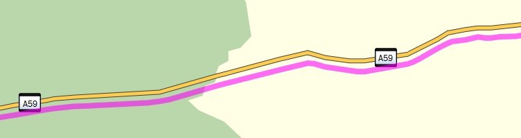
For every point in the route that I described above, I took the lattitude coordinate and shifted each one 0.001 south.
I then loaded the route into Basecamp to see what it looked like. See below.

file.php


So the whole route has been shifted south a little.

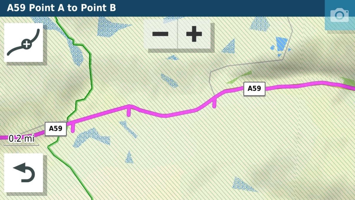
I then copied the same gpx file to the Zumo XT and imported it. This is what that produced.

file.php


Now this is interesting. The route seems to have put itself onto the road. Why that is, I don't know but I altered the coordinates by just 0.001 of a degree, so perhaps it is the proximity. But every now and then there is a tick mark, and just looking at their position, these may well correspond with where the subclass lines are in the gpx file. I'd need to confirm that.

So what happens if I force this route to recalculate on the XT by changing it to a car route and then back to a matorycle route?

The tick marks disappear.

So that sounds like an answer to me. The ghost points of the original gpx route do not plot onto actual roads on the map on the Zumo. The ticks are where the subclass statements have appeared in the route.
Recalculating a route does away with all of the ghost points and subclass satements and the satnav generates a new route from the via points and shaping points that it has. These too may be slightly off route, but the satnav still navigates on the nearby roads.

I hope the pictures show up OK. I've had to place them somewhere else.
 
So, what you are saying, John, is that somehow in its first creation of the route, my Nav V has forgotten to alter the coordinates of the thousands of invisible points in the route between the shaping points. And that, without the thousands of coordinates, it can only render up straight lines. But, in the conversion from fastest time to curvy it remembers and remembers again when it’s converted back. Is that the gist of it?

If the cause of the forgetting is a soft or firmware issue, then we might bet that there are hundreds of Nav V’s whose owners are about to be in for a surprise.
 
I cant see this being an issue with just yours or the Rustle sat nav Richard it will either be batch wide or software/firmware related, and with reference to this from Jfheath (I think that somewhere, for whatever reason the calibration data for the route or for the map are out of synch.) surely if the calibration data for the route was out it would manifest itself in all units or am i wrong, if it was the calibration of the map data that i could understand, as long as it was unit (nav V ) specific, in other words something has changed on Richards and Rustle nav V and maybe many more due to maybe updates from Garmin.
 
No. I'm not saying that at all.

If the route is recalculated, the original ghost points disappear. The unit recalculates a new route and presumably pins it in place with new ghost points.
If the route doesn't recalculate, the original route stays as it is.

I have seen straight lines appear in routes that simply have the main route points. Recalculation always fixes these.

It is worth noting that GPX isn't a universal file format. When it was developed, companies wanted to add there own features - extensions. So there is a basic GPX structure, and there are optional extras. Garmin use these 'extensions' quite widely. But any softwre should be able to read Basic GPX features, and not be balked by other companies' extensions. It just ignores them. SO when you load a gpx file into Basecamp and then send it somewhere else, Basecamp may have altered the gpx file. It will have ignored all extensions that it doesn't know about and maybe added some of its own when it interpreted the route.

If the route is passed from one device to another, then the device itself could have manipulated the route. The XT for example will take some of the information it has received and rename the location presumably based on coordinates. In other situations a location may actually be moved by the XT. I have no evidence that these two things can happen at the same time, but I think that I have seen it twice. I've not been able to reproduce it though.

I'm not being very scientific. I'm throwing stuff that I know into the mix in case it is relevant. The problem that I have is that I came into this late. I don't know how the original route was created, on what maps, on what software, and I don't have a Nav V to try things out on. I only have a 590 or 595 if I set it up in that way and an XT.
I don't know what profiles and settings were set up in Basecamp or how the GPS was set up when it received them.

I have not seen Garmin maps get of of synch with garmin routes. But I have seen / proved that maps from other sources can produce points on one map that are plotted differently on another map. The coordinates are the same. The maps are drawn differently. Google roads with Garmin maps fell into this category in couple of tests that I did a few years ago.

For whatever reason, I think that there has to be something different about the route or the maps. My illustrations above (where I deliberately relocated the route) seem to support this.

I'd be curious to know how the position of route points (shaping or via or waypoints) compare on different units.

Let me go back and see if I can tease out the information that I need.
 
This statement (I have not seen Garmin maps get of of synch with garmin routes) is exactly what we are talking about, we have Garmin routes not working with Garmin maps, the exact same maps, the map that was downloaded from garmin and installed to a pc and the exact same map onto the nav unit. or is it that you are thinking that the downloaded maps to the pc and the installed maps on the navs are some how different from one another and are not exact. surely if that was the case my routes would not be correct on Richards nav

I have downloaded many routes from various sources Garmin and none Garmin, and like yourself have seen all manner of straight lines and and discrepancies. but never have i sent a route from my own basecamp to my own sat navs and had the likes of what is happening with the nav V of Richard and Rustle.
 
Hi John, thank you for your help, really appreciated. I am with Lee on this.

The routes are being created in BaseCamp, me on my home computer, Lee on his and Rustle (whose opening post started the affair) on his. I can’t pretend that our settings or even maps are the same but I really don’t think that matters. I can explain why, as follows:

Each of the routes displays properly in BaseCamp on our (mine, Lee’s and Rustle’s) home computers. Each of the routes displays properly if I send them to my XT, into MyRoute, into Pocket Earth and into say, Garmin Drive or BMW Connect. Similarly, Lee (an experienced user) tells me that the routes display properly on his devices, none of which are a Nav V. As far as I can tell, the only time a route does not display properly is when it is opened up on a Navigator V. Had I of had my Nav VI I’d have been able to check whether or not that too showed the same corruption.

On the same grounds, if I send the route from my home computer to my XT and from there to my Nav V, it displays properly (ie uncorrupted) on my Nav V, too. I can summarise as follows:

1. Route created by me in BaseCamp on my home computer is fine.

2. Route created by someone else in BaseCamp on their home computer, then displayed by me in BaseCamp on my home computer is fine. The only glitch is that the route displayed on my home computer doesn’t always show an estimated journey time. I do not understand why the journey time is not shown.

3. Routes 1 and 2, when sent by me to Pocket Earth, to my XT, to MyMap and / or to other software, display fine.

4. Route 1, when displayed by Lee on his home computer and on his non-Nav V devices, is fine.

5. Routes 1 and 2, when sent by me and Rustle to our Nav V devices are corrupted, when displayed in our Nav V’s. They show the shaping and via points correctly positioned but these points are joined by straight lines only. As a consequence the milages and journey times leap. This corruption can be mended within in the Nav V itself if the route is then converted by the Nav V from fastest time to curvy roads and back to fastest time. Having been converted, the Nav V then displays an uncorrupted route, correct in mileage and estimated journey time.

6. Route 1, created in BaseCamp on my home computer, then sent to my XT and from there to my Nav V, displays fine on my Nav V.

It is therefore ONLY when a perfectly good route, created in BaseCamp is sent from a home computer to a Nav V, that the corruption manifests itself. If I had my Nav VI to hand I would be able to check whether that device showed the same corruption. That being said, Lee is reporting no corruption with his non-Nav V devices. Another correspondent in the thread is reporting that the routes (though corrupt in the Nav V) are displaying OK on his Montana. This would seem to confirm that the corruption is ONLY (so far at least) manifesting itself in the Nav V. You can check for yourself with your devices (please do) if you use the uncorrupted route in post #95. Does it display properly in BaseCamp on your home computer AND on your devices?

Like, you and Lee, I am used to seeing straight lines on routes, particularly when they come from third parties, like German touring magazines or have been created outside of the Garmin environment. Similarly, Lee and I have often helped correspondents to UKGSer sort out straight lines in their routes, often with 100% success. In short, we are pretty familiar with the foibles coffee GPX, realising that it is not always perfect. What though neither of us has ever seen is the corruption that is occurring to otherwise perfectly good routes, when they are displayed in a Navigator V. It really is something new and something neither of us understand.

The last two sentences in the paragraph above sums it up for me. The corruption appears unique to the Nav V’s owned by me and Rustle. Whether it is also manifesting itself in other Nav V’s I have no way of knowing. I used to have a second Nav V but I sold it, so I can’t check for myself. I have put an appeal out on UKGSer (where there is lots of Nav V devices in use and I guess at least some users of BaseCamp) but there has been zero response, sadly.

I won’t pretend that I fully understand the computer coding that sits behind routes, though I can follow what it is you are saying in post #98 and can understand that any Garmin type device needs to align its maps and have known coordinates for each each and every ghost or actual shaping / via point in order to properly display a route. In a way that is no different to me with a paper map, where I need to know the scale, which way up to hold the map and to know the map coordinates of points in order to accurately mark a spot on the map. All that is doubtless true and I fully accept it. What though it doesn’t explain - at least not to me - is why the corruption is occurring to otherwise perfectly good, well constructed BaseCamp routes when displayed in the Navigator V’s owned by me and Rustle. That is what I want the answer to.

Richard

PS The only thing I haven’t tried is creating a route in MyRoute, sending that to BaseCamp and from there into my Nav V. I’ll give that a go.
 
PS The only thing I haven’t tried is creating a route in MyRoute, sending that to BaseCamp and from there into my Nav V. I’ll give that a go.

Here is the route I have created in MyRoute for the test:

https://www.dropbox.com/s/ai9ck129dj7d1ql/Navigator V test route only.gpx?dl=0

Or try MyRoute users can maybe try:

https://www.myrouteapp.com/en/social/route/5653834?mode=share

It looks like this:

30c94f3afab46e211dfaf6a37ae22976.png


It is 822.64 miles long and shows an estimated journey time of 18 hours 10 minutes.

What I’ll be interested to hear is:

A. Does it download properly into BaseCamp?

B. Does it transfer properly into non-Nav V devices and software?

C. Does it transfer properly into a Nav V?

I can check all three but it would be useful to hear from others, too.

Thank you.
 
As i expected coming from MRA i get a route consisting of a very straight line and a track of the actual route as it should look, if i then convert the track to a route i end up with a perfect copy of your above route in the picture.
I then recalculate the straight line route using the settings i have in my basecamp and get a Route different to your route, Why because my settings are different than the ones used to create the route. The green route is the one that has my basecamp settings.

Sorry pictures are in reverse order. also the last pic was the route loaded into mapsource.
 

Attachments

  • 11.jpg
    11.jpg
    258.5 KB · Views: 45
  • 22.jpg
    22.jpg
    274.6 KB · Views: 47
  • 33.jpg
    33.jpg
    267.7 KB · Views: 45
Thank you, Lee, that’s great and just what I expected you’d see / experience.

One last request. Can you send the route to from BaseCamp to your devices please. It should export perfectly.

Richard
 
as expected Richard on my stoneage abacus the route was to long to load in one go so split the route and all displayed as it should. pics of split route they are perfect when zoomed in
 

Attachments

  • 20220304_093511.jpg
    20220304_093511.jpg
    252 KB · Views: 37
  • 20220304_094204.jpg
    20220304_094204.jpg
    252.5 KB · Views: 39
as expected Richard on my stoneage abacus the route was to long to load in one go so split the route and all displayed as it should.

Thank you, Lee.

I realised only after I had made the route that I had made it too long. That was a schoolboy error on my part. That being said, your report that it loaded OK into non-Nav V devices is encouraging.

My report back will be available shortly.
 
Even the distance was to the mile Richard and i know my maps are a different map set to yours.
 
Gents, I'm not ignoring your efforts, I've prepared a random Italian route as another test for my PC/Nav 5 in the interim. BUT, I can't get the Nav to be recognised by the PC ie another of my earlier problems. It was connecting when I was able to confirm a Danish test route transferred precisely but now, no joy. I've tried some options suggested on the other thread but still no luck. Maybe it will connect at random soon? I had a daft thought - my UK routes have always worked successfully over the past two years but, as you know the France + Spain ones didn't. If the Danish one works too, is it possible that the potentially corrupted mapping is in the South Europe part alone? (Yes, it is green ticked on my device)
 
At the moment Rustle it could be something completely unrelated to the maps or it well could be the maps, one thing for sure the problem does exist and seems to be nav V related or not :aidan:aidan
 
Length of trial run route notwithstanding, here’s my results:

1. The MyRoute route loaded into BaseCamp in exactly the same way as Lee’s and just as I expected it would.

It shows the track (I have coloured it red) and a magenta straight route line A to B. The track length is spot on at 822 miles.

53e155c793abeaeeac8d5d5fb70963a5.jpg


2. I deleted the straight line version of the route and asked BaseCamp to create a route from the track. This it did, perfectly. The distance is correct at 822 miles and the estimated journey time is a not unrealistic 17 hours and 7 minutes. This compares with MyRoutes 822 miles in an estimated 18 hours 10 minutes. I am not going to quibble over time estimates which are pretty subjective anyway. The important thing is that the long route is perfect in BaseCamp.

333b09266353eac419c247e726f29a25.jpg


3. I exported the track and the route to my Nav V.

4. The track exported perfectly.

5. The route, after a not unsurprisingly long wait, exported perfectly, too:

13ccc7075b21cd27835d3ba11516ccc9.jpg


5feca6d679af563dd8664a2a7d1348c4.jpg


bd75ca294b957555b7a2aac5da3af1b9.jpg

6737cd9474699200f784b238d8715d8f.jpg

d6a257dcc0700b28a0d33e2e7869d97b.jpg


The distance is correct at 822 miles, the shape is correct, it is snapped onto the roads. The estimated time differs again but that doesn’t surprise me. The shaping points (little blue dots) are not shown but that is normal for a route from MyRoute that is exported into Garmin in version 1.2, so that doesn’t bother me.

6. The route exported perfectly from MyRoute, via Garmin Drive, into my XT.

CONCLUSIONS

A. It is a very long route, way longer than most (sensible) people would create as a single route. But its length implies some considerable computing / conversion / installation power. If something is going to fall over or be corrupted it would be this.

B. There was NO corruption of the route between BaseCamp and my Nav V.

That being said, the route was created from a converted track, so I am not sure what implication that might have. Irrespective, it is the complete opposite of the past few days findings where, routes created directly in BaseCamp were arriving corrupted in my Nav V, each and every time. This applied to whether they were created by me, Lee or Rustle. The result was always the same, the Nav V corrupted the route; a corruption that could only be remedied by conversion within the Nav V itself.

C. It casts a bit of doubt on the theory that it might be the maps used that cause the problem. MyRoute is a very different map to Garmin’s and Lee is using a different Garmin map edition to me, but the transfer and rendering of the very long, quite complex, route is perfect.

D. MyRoute can be used for route creation into Garmin devices. But I knew that anyway. It is simply good to have it reconfirmed and to be sure that it doesn’t bring a huge glitch with it.

E. I still don’t understand what causes the corruption between BaseCamp and my Nav V that I and Rustle have been experiencing. But at least I think we can narrow it down to being only on routes created directly in BaseCamp and exported directly into the Nav V. The jury remains out on the Nav VI as I haven’t got one to test with.

F. The workaround remains, recalculation in tge Nav V. To which can be added, creation of the route in MyRoute, then bouncing it through BaseCamp (see method above) and then out to the Nav V.
 
E. I still don’t understand what causes the corruption between BaseCamp and my Nav V that I and Rustle have been experiencing. But at least I think we can narrow it down to being only on routes created directly in BaseCamp and exported directly into the Nav V. The jury remains out on the Nav VI as I haven’t got one to test with.

Now that I know this, I am going to do some more playing about.

I am going to:

A. Turn all the route preferences off in BaseCamp and on my Nav V. I have very few turned on, but who knows, maybe those one or two are upsetting the apple cart.

B. Shut down my Mac and Nav V completely, just in case there is some update that is hanging around uninstalled. I know I have done it before but I’ll do it anyway.

C. I’ll create three or four more short 50 to 150 mile test routes in various countries, all made directly in BaseCamp and exported directly to my Nav V, to see what results I obtain.

If C is still giving corrupt results, I’ll give up, admitting defeat.
 
the problem i see is that you have never had this issue with basecamp and the nav V before, so has something changed, we know you make routes that are all good, so that is not the issue, we know that all your routes transfer to your XT and my navs perfectly and also from MRA, the only fly in the ointment i see is the nav V, I may be wrong but at this point to me anyway thats how i see it, maybe an update (it was ok before ) who knows???.
 
Hi Lee,

I agree with you. Whilst it’s easy to make mistakes, particularly when trying different settings in an effort to help people, then forgetting to change them back, I am pretty sure I can exclude user error in this investigation.

I shut everything down, cleared everything out of my Nav V, reset the preferences to zero on the device and in BaseCamp and reconfirmed the maps are identical *. I then created three trial routes directly in BaseCamp. One in France, one in the UK and one in Denmark. Each is perfect in BaseCamp, perfect when shared into MyRoute and Pocket Earth and on my XT.

Each one is corrupted when displayed on my Nav V, the corruption being the same spikes, crazy distances and bonkers times. The conversion to curvy roads and back to fastest time, resolves the corruption, just as it did yesterday.

Between us all we have now run through just about every permutation available to us. I have drawn a complete blank as to its cause, though we do know the cures.

The glitch has to lie somewhere between BaseCamp and the Nav V. It can’t be a pure Mac thing as Rustle uses a PC. Whilst his knowledge of IT is only marginally worse than my own, I can see from the test route he shared with us that he knows how to use BaseCamp, so I think we can exclude user error there. Had it just been his Nav V or mine, then I’d think it was just bad luck. But to have two, miles apart and completely unconnected tells me it has to be some sort of update glitch, which only Garmin can fix.

I think that’s me done on the matter I’m afraid. Annoying as UKGSer has a pretty good track record of fixing problems. This one has escaped us. Thank you though to Rustle for flagging it up. There is a chance that you are first in the world to spot the corruption, as I certainly can’t find anything recent through Google about it. It’s been fun, of a sort, trying to mend it.

Richard

* On the map front. BaseCamp, at least on my Mac, is configured to match routes in BaseCamp to maps on the device on transfer. I guess this reduces or removes unintended errors.

da1863b77523497f9f30f89ef052bf79.jpg
 
Haha! Richard, my IT skills marginally worse than yours? You're mad you are. I'm at the early Hominid stage when it comes to IT whereas you and Lee etc are round about today's date!

Meanwhile, after a lot of plugging in and long waits and trying the other USB on my PC and re-booting when plugged in, plugged out and any other Hockey Cockey permutation imaginable, I have managed to connect! T tested my made up route in Italy and it maps correctly on the NAV 5 with sensible times. Basecamp for my route claims 98 miles @ 2hr 50 whereas Nav 5 says 100 miles and 2.40. That's as spot on as you might get. My South Europe corruption notion might just be, as we say here, total mince!

I will now try another Spanish route to confirm things generally seem to be ok.:wave
 
I made up a wacky, slightly complicated, and long route in Spain. Basecamp says 321 miles & 7hr 30mins. Nav 5 (which I didn't disconnect from the Italy route download - frightened I'd lose connection again!) says 328 miles and 6hr 50mins. That'll do me! Reminder - I had previously confirmed Express and the Nav 5 were up to date but had discovered that Basecamp was a stage behind. I re-installed the maps on the Nav and updated Basecamp so, in theory, they are all on the same hymn sheet. All of this, mark you, with all your guidance! Very little of my knowledge featured at all. Settings on Basecamp and Nav 5 were checked and confirmed to have been the same. I don't want to tempt fate, if there is such a state, but it looks as if my "equipment" is working well. I am not complacent however since you fellas seem to have managed to replicate the original problem and are working towards a conclusion/solution. Until you are convinced, I'm sitting on a slightly comfortable fence. :thumb2
 
Status
Not open for further replies.


Back
Top Bottom